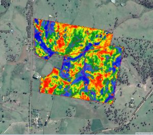
SOIL NUTRIENT ZONE MAPPING
Achieve optimal pasture production with a detailed picture of your nutrient profile.

Subscribing to Precision Pastures biomass imagery service gives you access to regularly updated, NDVI-enhanced satellite maps of your property.
Our biomass maps use infrared and near-infrared light to index the active growth rate of your vegetation. This provides a detailed picture of the biomass quantity and quality on your farm, at a glance.
As a result, you will be able make more confident feed budgeting and drought-proofing decisions – and forecast livestock performance with greater certainty.
Make improvements based on data, not assumptions
Save on lime, nutrients and amendments
Automate the spreading process
Track progress and performance over time
our process
1. CONSULTATION
Precision Pastures will work with you find a solution that fits your budget. This includes selecting the number of paddocks and nutrients to sample. We will also help you set clear, measurable pasture goals.
2. SAMPLING
Using a GPS enabled 4WD quad, we will log your paddock boundaries and sample on a 1-2 hectare grid. The sampling process may take a day or more, depending on the size of your project.
3. RESULTS
The turnaround period from sampling to results is 2-3 weeks. Your results will be delivered in person or by phone, along with detailed recommendations for the actions you should take. Your results package will include
- A suite of paddock maps, with variations in macronutrients clearly zoned
- Tabulated soil test results
- Calculators for required nutrients
- Capital application timelines
- A Variable Rate (VR) prescription
4. VRA ASSISTANCE
If you decide to proceed with variable rate application, we can deliver our VR prescription data directly to the spreader of your choice.
5. MONITORING
Because we GPS log each sample site, we can periodically re-sample to track your progress at an even more cost effective rate.

